Easy Contour
com.tyevolution.EasyContour
Total installs
0+
Rating
0.0
Released
May 10, 2013
Last updated
February 10, 2024
Category
Utilities
Developer
元荃 李
Developer details
Name
元荃 李
E-mail
unknown
Website
unknown
Country
unknown
Address
unknown
iOS SDKs
- No items.
Screenshots


Description
Easy Contour is a 3D visualization, contouring and surface modeling package that runs under Mac. It is used for terrain modeling, landscape visualization, surface analysis, contour mapping, 3D mapping, gridding, and much more.
Feature layer (point, line, and polygon layer)
• Add and edit points, lines, or polygons
• Render type: Simple, ClassBreak, Categories (according to the attribute table)
• Symbol layer type of point layer: Simple marker, Character marker (You can enter any character)
• Fill type of polygon layer: Simple, Gradient, Hatch, Picture
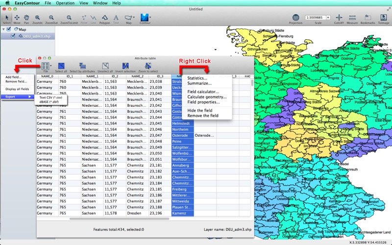
* * * * * Attribute table * * * * * ( See the third screenshot below )
Interpolation (kd-tree searching mechanism)
• Type:
(1) Inverse Distance (IDW)
(2) Modified shepard
(3) Nearest neighbours
(4)Nature neighbours
(4) RBF-QNN
(5) RBF-ML
(6) Simple kriging
(7) Ordinary kriging
• Get point M data from attribute table for interpolation
Contour
• Grid transformation
• Grid math
• Grid extracting
• Grid function
• Grid blank
• Grid report
Projection system
• Geographic systems, Projected systems
• Projection transformation
Voronoi and Delaunay triangle
• Build voronoi polygons according to points, and get to the points of attributes
• Build Delaunay triangle according to points, and add attributes
Import
• Scatter plot (*.txt, *.dat, *.csv, *.tab) (The points coordinates and attributes are automatically added to attribute table while importing Text file.)
• ESRI Shapefile
• Binary golden software grid 6/7 (*.grd)
• ASC Arc/Info ASCII Grid (*.asc, *.aig, *.agr, *.grd)
• USGS DEM (*.dem)
• DXF (*.dxf)
Export
• ESRI Shapefile (*.shp, *.shx, *.dbf, *.prj)
• Image (*.pdf (vector), *.jpg, *.png, *.tiff)
• DXF (*.dxf)
When export contour lines, you can put the contour value on elevation.
• GRD Surfer 7 Binary Grid (*.grd)
• ASC Arc/Info ASCII Grid (*.asc, *.aig, *.agr, *.grd)
• KML (*.kml)
Online Help
http://www.tyevolution.com/nr.jsp?_np=0_315_2
Video tutorial
https://www.youtube.com/playlist?list=PL3BrLKH7Kamtk-JxGk9dnixptt3j9RBU0&spfreload=10
Blog
http://tyevolution2014.blogspot.com/